Monday, July 30, 2007

Victoria, BC


While in this part of Washington a visit to Victoria, Canada (an island just off of the Canadian mainland) was high on the list. The above is a pic of the passenger ferry that takes about 55 minutes to cross the Strait of Juan de Fuca. Of course should you wish to take your vehicle for an extended stay, the next photo shows the vessel to take.

Victoria, BC


A photo of the "Coho" another passenger and vehicle ferry going between Port Angeles and Victoria. The ship takes on small cars as well as 18 wheel truck/tractors.

Victoria, BC


Looking back toward Port Angeles as we headed for Victoria (about 29 miles).

Victoria, BC


A pic of the stern of this cargo ship as we passed by headed toward Victoria. The small boat on the right is a pilot boat that assists large vessels out of port and into the Strait of Juan de Fuca.

Victoria, BC


After passing by the ship the pilot tugboat made a quick u-turn to ride in the wake of our boat as we headed toward Victoria (a smoother ride for sure).

Victoria, BC


A pic of a shuttle craft that is very popular amoung tourist and locals alike. There are at least a dozen or so navigating the waterways of Victoria at any given time.

Victoria, BC


Thought a pic of this private yacht would give a good comparison as to how some people travel compared to the passenger ferries and harbor shuttles.

Victoria, BC


Just across the street from the main harbor is the Empress Hotel a landmark for this city. It is the finest (and most expensive) hotel in Victoria.

Victoria, BC


Yours truly at a small fountain/garden area off to the side of the Empress Hotel.

Victoria, BC


A look just inside the door of the "Bengal" room at the Empress Hotel. Nothing cheap about this place. A cup of tea (with crumpets of course) during "High Tea" hour, will cost you $65.00.

Victoria, BC


Trumpet flower tree alongside the Empress Hotel

Victoria, BC


While visiting the city, decided this would be a great way to get around to see the sights. This is about a 1 1/2 hr tour. We sat up top of course.

Victoria, BC


During our tour, thought this photo was worth posting. A newly completed upgrade to the city park shows a "water can" attraction for those wishing to cool off.

Victoria, BC


This town has many old churches with varying designs. An example noted above.

Victoria, BC


A view of Chinatown (has the largest population in Canada)

Victoria, BC


Another government building built in the 1920"s (as was the parliament building shown next)

Victoria, BC


A photo of the Parliament building just across the street from the harbor This structure is illuminated by small white lights at night making for a very striking appearance.

Victoria, BC


A pic of the Oak Harbor Marina just east of downtown Victoria. This Victoria suburb is an upscale community and is surrounded by some very exclusive homes.

Victoria, BC


This pic shows the beach in the Oak Harbor area. Nice beach but not too many people were in the water. Our tour guide mentioned the water temp was around 50 degrees and just does not get much warmer.

Victoria, BC


A photo showing part of the boardwalk around the harbor area. Note the "mermaid" to the left.
Lots of vendors and entertainers that go for about 1/4 mile.

Victoria, BC


A closer look. This gal would sit motionless for quite awhile until someone passing by would put a coin in her basket. Then she would start up playing for 2-3 minutes and just shut down until the next person would add a donation.

Victoria, BC


This sea plane was just preparing to land just past our boat leaving the Victoria harbor marina.

Victoria, BC


Since the sea plane was taking off just behind and to the right of our boat, thought I would post this pic. These planes land and/or takeoff about every 5-10 min. in the harbor channel.

Wednesday, July 25, 2007

Hurricane Ridge


After arriving in Sequim, Washington from Forks, one of our "must do" visits was to Hurricane Ridge, Olympic National Park. There are trails and pathways for the beginner or the advanced hiker. A great day and the weather could not have been more perfect.

Hurricane Ridge


A view of the Olympic mountains. This area called Hurricane Ridge gets this name because winds can exceed 100 mph during winter storms. On the left side of this photo (below the mountain ridge) you can see a small white patch within the trees. Mt. Olympus (the highest point in the range - 7960 ft) is just above that mark and slightly to the right along to ridge line.

Hurricane Ridge


My better half looking at the Olympic mountain range (with the binoculars) while at the visitor center.

Hurricane Ridge


Just strolling through the visitor center area. Obviously quite use to people. This black tail doe is a cousin to the mule deer seen further south.

Hurricane Ridge


As shown in the next photo.

Hurricane Ridge


That area in the top center of this photo is that described in the previous sign. There are tree trunks in that area but all were pretty much dead.

Hurricane Ridge


Looking due north from the ridge with the Strait of Juna de Fuca and Victoria Island, BC. Very hard to see, but Victoria is almost in the center of this photo. Since the altitude in this area is close to the tree line, the dense forest is pretty much gone.

Hurricane Ridge


A pic of one of the more accessible pathways in the ridge area. This one is asphalt so that handicap individuals can also enjoy the outdoors as well.

Hurricane Ridge


A look from one pathway around the ridge area. That building is the visitor center.

Hurricane Ridge


A photo looking back down the mountain and the roadway below.

Hurricane Ridge


Put the camera on a bench, set the timer and here we are.

Hurricane Ridge


While having lunch in the picnic area this chipmunk came looking for any handouts. Of course, per the multiple notices around Olympic National Park, "do not feed - keep the wildlife wild".

Hurricane Ridge


Coming back from the ridge pulled into a turnout to get a pic of the peninsula and the Strait of Juan de Fuca.

Hurricane Ridge


On the way down the mountain, just had to take a photo of this black tail doe trotting alongside the roadway.

Friday, July 20, 2007

Lake Crescent/Marymere Falls


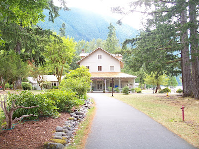
Before leaving the western side of the Washington peninsula, wanted to take a trip to the Crescent Lake area. The above is a photo of the Crescent Lake Lodge. The next photo was taken looking just to the right of the lodge over the lake. A nice place to spend a few days.

Lake Crescent/Marymere Falls


A view from the eastern shoreline. This lake is very big and, of course, is formed in a crescent shape.

Lake Crescent/Marymere Falls


Crescent Lake is bordered by very high mountain ranges and was formed from glaciers that were more prevalent a few thousand years ago.

Lake Crescent/Marymere Falls


The sign leads the way.

Lake Crescent/Marymere Falls


While looking around Crescent Lake, thought a trip to the local falls would be a good. As you can see, the falls (about 50' in height) is a very nice view.

Lake Crescent/Marymere Falls


There are several foot bridges along the way.

Lake Crescent/Marymere Falls


A closer look from the photo above - the width only allows one-way traffic.

Lake Crescent/Marymere Falls


A nice path toward to the falls

Wednesday, July 18, 2007

Sol Duc Valley/Falls


A nice day trip to Sol Duc Valley (part of the Olympic Nat'l Park system) was planned as they have a a cool path to the falls as well. The above is a pic of the Sol Duc River (downstream from the falls)

Sol Duc Valley/Falls


The pathway up to the falls. This forest is very scenic - lots of green of course.

Sol Duc Valley/Falls


The above is a pic of a shelter for mountain hikers as they travel beyond just one day. Not much to it, but certainly keeps the elements a bay.

Sol Duc Valley/Falls


A great view of the falls.

Sol Duc Valley/Falls


A closer look